We are delighted to announce the signing of a landmark agreement with Water Solutions Pvt Ltd to establish a GNSS & CORS Surveying System in Noonu Atoll. This initiative represents a pivotal step in leveraging advanced technology to empower our community, strengthen natural resource management, and enhance land use, infrastructure development, and resilient environmental planning.
As stewards of our islands, we hold a deep collective responsibility to protect our natural resources—our land, marine ecosystems, and unique biodiversity—for future generations. The GNSS & CORS system is a vital tool in supporting evidence-based efforts to conserve these resources in the face of climate change, rising sea levels, and ongoing environmental challenges.
Key Project Activities
Installation of a Continuously Operating Reference Station (CORS): Located at the Council premises, the station will provide real-time, high-accuracy GPS data to inform conservation and planning decisions.
Deployment of GNSS Base and Rover Receivers: Offering operational coverage of over 25km from Manadhoo, enabling comprehensive resource mapping and environmental assessments.
Integration with GIS Systems: Facilitating smart and sustainable planning of roads, utilities, zoning, and protected areas—supporting ecologically sensitive development.
Delivery of Handheld GPS Devices: Empowering on-site surveys for island councils and technical teams to monitor shoreline movement, land use, and habitat health.
Comprehensive Training Programmes: Equipping council staff with skills in system operation, GIS workflows, climate risk assessment, and environmental monitoring.
10-Year Maintenance and Support Services: Ensuring reliable long-term operation and continuous support for climate adaptation efforts.
Why This Matters for Our Community
Natural Resource Conservation: The precise mapping and monitoring capabilities will help preserve vital habitats, manage coastal resources, and promote sustainable land use—protecting our fragile ecosystems from overexploitation and degradation.
Climate Change Adaptation: Enhanced data will allow us to track shoreline changes, assess flood risks, and design defenses against rising sea levels, supporting proactive adaptation for vulnerable communities.
Better Land Use Planning: Accurate boundary mapping, fairer land allocation, and ecologically balanced zoning for housing, agriculture, infrastructure, and conservation efforts.
Faster, More Accurate Surveys: Reducing delays and costs for public and private sector projects, and enabling swift response to environmental events.
Climate Resilience: Strengthening our ability to monitor and respond to changing environmental conditions, fostering sustainable development in harmony with nature.
Data-Driven Decision Making: Supporting councils, developers, and community organizations with real-time spatial data for transparent and inclusive governance.
Boosting Local Economy: Encouraging sustainable investments, supporting micro-enterprises, and accelerating environmentally responsible project timelines.
Youth Empowerment: Building local capacity in GIS, modern mapping technologies, and conservation methods, empowering the next generation of leaders in sustainable development.
Other Progress

Looking for a party to maintain vehicle driving license track
Noonu Atoll Council Secretariat is seeking registered businesses to clean & maintain the vehicle driving license track. Interested parties must register by Aug 12, 2024, & submit bids by Aug 18, 2024.
Noonu Atoll Council
announcement

Seeking a Speedboat Driver
Noonu Atoll Council seeks speedboat driver. Responsibilities include boat operation, maintenance, and office support. Apply by July 23rd.
Noonu Atoll Council
jobs

Seeking a Senior Accounts Officer
Noonu Atoll Council is hiring a Senior Accounts Officer! Manage finances, implement development programs, & oversee staff. Competitive salary & benefits. Apply by Dec 21st, 2023.
Noonu Atoll Council
jobs

Looking for a qualified party to transport goods
Noonu Atoll Council seeks a qualified party to transport goods from an uninhabited island. Register by Oct 31, 2023, & submit bids by Nov 7, 2023. For more info, contact procurement@noonu.gov.mv or 6560012/6568501.
Noonu Atoll Council
announcement
Invitation for Bids: A supplier for laptops and tablets
Noonu Atoll Council seeks a supplier for laptops & tablets. Register by Oct 18, 2023, & submit bids by Oct 23, 2023.
Noonu Atoll Council
announcement
-pZSgV.webp)
Invitation for Bids - Introducing Drone Survey Technology for Noonu Atoll
We're introducing Drone Technology to improve land use planning, manage resources, and protect our environment in Noonu Atoll! We invite bids to supply drones, software, mobile stations & training. Join us in shaping a sustainable future.
Noonu Atoll Council
announcement

Seeking MICE Tourism Expert to Premier Convention Facility
Noonu Atoll Local Authority Company seeks a consultant to handle the comprehensive development, management, and training for a MICE tourism facility in Noonu Manadhoo. This includes the creation of operational SOPs, service guidelines, and ensuring full compliance with industry standards. Apply by July 13, 2024
Noonu Atoll Company
jobs

Seeking a Chief Sustainability Officer (CSO)
Noonu Atoll Local Authority Company seeks a skilled CSO with expertise in sustainability leadership, environmental management, and fundraising to oversee Noonu Atoll LAC's sustainability initiatives, including Natural Resources Management, Conservation & Restoration, Sustainability Reporting & Stewardship, and Sustainable Finance. Apply before June 15, 2024.
Noonu Atoll Company
jobs

Invitation for Bids: Office Space Enhancement and other renovation works
Noonu Atoll Company hereby announces an invitation for the submission of proposals for Front Office Works, Deck Fabrication, and Completion of Two-Storey Building at Noonu Atoll Council. Submit by 06 June, 2024.
Noonu Atoll Company
announcement

Seeking a Visionary Chief Operations Officer (COO)
Hiring a Chief Operating Officer (COO)! Do you have a proven track record in operational leadership & a passion for driving success?
Noonu Atoll Company
jobs
Seeking Multi-Talented Admin Officers
Hiring Admin Officers for Front Office & Public Relations! Do you have strong communication skills & a passion for creating positive impressions?
Noonu Atoll Company
jobs
Invitation for Expression of Interest: Satellite Imagery Acquisition Services
Noonu Atoll Local Authority Company seeks experienced vendors in the provision of satellite imagery acquisition services. Submit before 08 April, 2024.
Noonu Atoll Company
announcement
Seeking a Chief Technology Officer (CTO)
Noonu Atoll Company is hiring a CTO! Lead our tech strategy & drive innovation. Competitive salary & benefits.
Noonu Atoll Company
jobs

Seeking a Civil Engineering Consultant
Hiring a Civil Engineering Consultant! Develop project plans, manage construction, & provide technical expertise.
Noonu Atoll Company
jobs
Seeking a Chief Financial Officer (CFO)
Noonu Atoll Company is hiring a CFO! Lead financial operations, strategy, and reporting. Competitive salary & benefits. Apply by Feb 11, 2024.
Noonu Atoll Company
jobs

Resolution for Amendments to the Land-Use Planning Act and the Urban Planning Bill
Council unanimously objects to the current design of the Urban Planning Bill and calls for amendments to the Land-Use Planning Act. We stand for local governance, community planning, and public consent. Let’s ensure our laws align with the Decentralization Chapter of the Constitution! #CommunityFirst
Noonu Atoll Council
press

Invitation for Bids: Post Land Use Plan Development Planning Consultancy for Noonu Kudafari
Noonu Atoll Company is seeking expert consultants for Post Land Use Plan Development Planning Consultancy for Kudafari! Join us in shaping Kudafari’s future and contributing to sustainable development. Register now
Noonu Atoll Company
announcement

Invitation for Bids: Establish a Comprehensive Business and Attraction Registry
Noonu Atoll Company invites bids for establishing a Comprehensive Business and Attraction Registry. Join us in enhancing local economic opportunities and supporting local
Noonu Atoll Company
announcement

Seeking a Legal officer
Looking for a fulfilling legal career? Noonu Atoll Council is hiring a Legal Officer! Ensure compliance, provide legal advice, and support our community. Apply by 21st Oct 2024.
Noonu Atoll Council
jobs

Noonu Atoll Joins the Strong Cities Network
Proud to announce Noonu Atoll’s membership in the Strong Cities Network (SCN)! Together, we’re tackling extremism and building safer, more inclusive communities—because everyone deserves to thrive. By joining SCN, we gain access to global resources and collaborate on innovative solutions to protect and uplift our people.
Noonu Atoll Council
press

Showcasing Citizen-Centric Vision at Maldives IGF2024
Noonu Atoll Administration proudly showcased Citizen Centric Governance Program at the Maldives IGF 2024! We shared how we’re leveraging technology to enhance service delivery and citizen engagement.
Noonu Atoll Council
press
Invitation for Bids - Re-Tender: Establish a Comprehensive Business and Attraction Registry
Noonu Atoll Company invites bids for establishing a Comprehensive Business and Attraction Registry. Join us in enhancing local economic opportunities and supporting local
Noonu Atoll Company
announcement
-Sid0_.webp)
Exploring MICE Tourism Opportunities with MITDC
Discussions with MITDC are underway to explore turning council-owned spaces, like the proposed Convention House in Manadhoo, into vibrant MICE tourism venues. 🌿 These initiatives aim to drive sustainable growth, boost local businesses, and empower our community. 🤝
Noonu Atoll Council
press

Appointment of Civil Engineering Consultant for Convention House Development Project
Civil Engineering Consultant hired for the Convention House Development in Noonu Atoll. Our vision is to create a versatile MICE destination, blending business and leisure facilities to boost jobs, support local businesses, and drive sustainable growth.
Noonu Atoll Council
press
-VjBKc.webp)
Deck Fabrication Completes Key Connection for Convention House, Enhancing Accessibility and Aesthetic
The deck fabrication at the Convention House complex is now complete. Through our collaboration with Newro, this project enhances connectivity, accessibility, mobility, and operational efficiency, while optimizing space. It reflects our commitment to sustainability and community development.
Noonu Atoll Council
press
-t6DEs.webp)
Walkway Construction – Convention House Development Initiative
The walkway at the Convention House complex is now complete. This achievement supports greater accessibility and connectivity, linking key spaces like the Convention Hall and Council Secretariat. Grateful to Noonu Supply for their dedication and excellent craftsmanship.
Noonu Atoll Company
press
-NsI4i.webp)
Empowering Digital Tools – A Shared Journey with North Thiladhunmathi Atoll
We shared an incredible learning experience with North Thiladhunmathi Atoll Council staff, exploring the entire Microsoft Office ecosystem. Tools like Outlook, Teams, Power Platform, became catalysts for productivity, communication, & collaboration—building stronger communities together.
Noonu Atoll Council
press
-Tm61o.webp)
Partnering with National Drug Agency to Establish Local Solutions for Drug Rehabilitation and Reintegration
We held a working session with National Drug Agency (NDA) to address drug abuse in Noonu Atoll. This collaboration focuses on reducing drug use, offering localized support, and aiding societal reintegration. Prevention, treatment, rehabilitation, and reintegration remain key priorities.
Noonu Atoll Council
press
-lwop7.webp)
Collaborating for Sustainable Waste Management with Zero Waste Maldives
We’re collaborating with Zero Waste Maldives to conduct waste audits across all 13 islands of Noonu Atoll, funded by the Ministry of Environment. This initiative focuses on hazardous waste management, working towards our shared zero-waste vision for a cleaner, sustainable future.
Noonu Atoll Council
press

Noonu Atoll Education Conference 2024 Highlights Progress and Plans
Educational leaders came together at the Noonu Atoll Education Conference 2024 to reflect on past achievements, tackle current challenges, and outline strategies for the future. Progress from last year was reviewed, and clear goals were set for the year ahead.
Noonu Atoll Council
press
-MICvd.webp)
Pioneering Administrative Excellence with PI Networks for Microsoft Business Central
We're transforming governance with PI Networks through Microsoft Busines Central! Enhanced financial management, streamlined operations, and smarter resource planning are boosting efficiency and transparency in Noonu Atoll. A scalable model for all.
Noonu Atoll Company
press
-wD9dy.webp)
Collaboration with Visual Propaganda to Revolutionize Community Engagement
We’ve signed an agreement with Visual Propaganda on 14 April 2024 to develop a new Public Engagement Platform. This step reflects our commitment to better serve you through improved access, transparency, and collaboration.
Noonu Atoll Council
press
-w7rmk.webp)
Agreement Signed with Maldives Space Research Organization for Satellite Imagery Acquisition and Platform Development
Our partnership with Maldives Space Research Organization, signed on 26 June 2024, is advancing GIS tech, natural resource registries & natural capital accounting. 🌿 Together, we're driving sustainable growth, smarter planning & ecosystem protection in Noonu Atoll. 🌍✨
Noonu Atoll Company
press
-2KeCF.webp)
Appreciation to the Maldives Government for Accrediting Participation in COP29
We thank the Maldives government for accrediting our participation in COP29. Our mission focused on securing climate financing & fostering global collaborations to enhance resilience & sustainability for Noonu Atoll. Together, we aim for a brighter, greener future.
Noonu Atoll Council
press
-94Z9J.webp)
Noonu Atoll and Velaa Resort Collaborate on 2025 CSR Strategy
Noonu Atoll Administration shared ideas with Velaa Resort to enhance their 2025 CSR strategy. Focused on sustainable development, waste management, & education. Together, building a resilient future.
Noonu Atoll Council
press
-b8Ogl.webp)
Noonu Atoll Development Mid-term Review and Business Planning Workshop for 2025-2027
Transforming plans into progress! 🌍 The Noonu Atoll Development Workshop 2025-2027 focused on crafting bankable social business models, fostering collaboration, and balancing social, environmental, & economic priorities. A united step toward sustainable growth!
Noonu Atoll Council
press

Collective Administration Through a Collaborative and Resources Sharing Structure with Atoll Council and Company
Excited to witness the transformative power of partnership! The Noonu Atoll Council and Noonu Atoll Company are setting an exemplary model for collective governance, resource-sharing, and sustainable development. Together, we can achieve more #SustainableDevelopment #CommunityResilience #NoonuAtoll
Noonu Atoll Council
press

Pursuing Climate Finance at COP29
At #COP29, Noonu Atoll is pushing boundaries to secure climate finance! Engaging globally to bolster local sustainability efforts, the Atoll is set on a path for resilience and a sustainable tomorrow. 🌱 #ClimateAction
Noonu Atoll Council
press

Collaborating with the Climate Vulnerable Forum (CVF): Showcasing Atoll's Resilience Strategy
Excited to engage with the Climate Vulnerable Forum at #COP29! Noonu Atoll is showcasing innovative resilience strategy designed for a sustainable, climate-resilient future. 🤝🌱 #ClimateResilience #CVF
Noonu Atoll Council
press
Invitation for Bids - Re-Tender: Lobby Area Construction at Convention House
Join us on an exciting journey as Noonu Atoll re-opens the tender for the Convention House Lobby Area construction! Enhance visitor experiences through your proposals. Register now—deadline 2nd Dec 2024. #noonunaturally
Noonu Atoll Company
announcement

Invitation for Bids - Dhivehi AI Transcription Service for Noonu Atoll Local Governance
📢 Calling all companies specializing in AI transcription services! We invite you to participate in our upcoming tender for "Dhivehi AI Transcription Service." Don't miss this opportunity to showcase your expertise and be a part of a cutting-edge project. Find all the details and submit your bid before the deadline. Let's revolutionize local governance together! #AI #Transcription
Noonu Atoll Company
announcement

Noonu Atoll Endorses Call to Deliver an Efficient Local and Subnational Loss and Damage Response
Noonu Atoll Council has officially endorsed the call to deliver an efficient local and subnational loss and damage response. 🌍💪 Together, we can address the challenges of climate change and ensure a sustainable future for all. #ClimateAction #Sustainability
Noonu Atoll Council
press

Ecoverse Regeneration Demonstrations with Dr Thomas J. F. Goreau
🌿 Join us in Noonu Atoll from 9th-16th December to experience transformative potential of ecosystem regeneration and be inspired to make a positive impact. #CommunityEngagement #NoonuAtoll #EcosystemRegeneration
Noonu Atoll Council
announcement

Reimagining Noonu Binaaveshi: A Community Led Journey Towards Atoll Scale Economy and Climate Resilience
Reimagine Noonu Binaaveshi” is a community led initiative by the Noonu Atoll Council and Land Sea Maldives to create a sustainable, inclusive future. Through local voices, smart planning, and shared action, we’re shaping a resilient Noonu where people and nature thrive together.
Noonu Atoll Company
press
Signing of Quadripartite Agreement to Deliver Post Land Use Plan Consultancy in Noonu Kudafari
We are working with the Kudafari Island Council, and the community to deliver consultancy services that will enhance and support the climate resilient development of the island.
Noonu Atoll Company
press

Seeking Administrative Public Relations Officer
📣 We're hiring! Join our team as an Administrative Public Relations Officer and contribute to transparent governance. If you have a diploma in Administration or a related field, 2+ years of experience in a similar role, we want to hear from you! Apply now.
Noonu Atoll Company
jobs
Partnership & Grant Agreement Signed with Land Sea Maldives
Thrilled to announce our partnership with Land Sea Maldives for the Noonu Atoll Binaaveshi Project. Working towards equitable land rights. Join us in building a resilient and inclusive future for all! 🤝🌱
Noonu Atoll Council
press

Join Us for the DigiGov Summit 2024!
Join us at #DigiGovSummit2024 from 28-31 Dec in Noonu Manadhoo! Be part of the movement shaping sustainable governance & climate resilience.
Noonu Atoll Council
announcement

Invitation for Bids – Urban Planning Consultant
Invitation for Bids! We're seeking an experienced Urban Planning Consultant for the "Reimagine Noonu Binaaveshi" Project. Help shape sustainable growth in the Noonu Atoll! 🌱 Proposals must meet outlined criteria. Deadline & details here
Noonu Atoll Company
announcement

Invitation for Bids – Legal Consultant
We need a passionate legal consultant for the "Reimagine Noonu Binaaveshi" project to handle legal issues concerning the leasing of uninhabited islands. Help us promote equitable land distribution and uphold land rights in Noonu Atoll.
Noonu Atoll Company
announcement

Invitation for Bids – Socio-Economic Consultant
We're seeking experienced professionals for innovative land use planning & social business development. Promote sustainability, economic growth, and community resilience.
Noonu Atoll Company
announcement

Panel Discussion Explores Decentralization, Inclusivity, and Climate Resilience
Noonu Atoll Council participated in the Anti-Corruption Conference 2024 to discuss decentralization, inclusivity, and climate resilience for vulnerable communities. Key concerns and actionable solutions were highlighted for more effective governance.
Noonu Atoll Council
press
Noonu Atoll Entrusts Business & Attraction Registry to Jazeera Hospitality
Business & Attraction Registry led by Jazeera Hospitality Maldives aims to empower local businesses, drive tourism & spotlight hidden gems. 🌊
Noonu Atoll Company
press
DigiGov Summit 2024 - Agenda & Partners
Here's what's on the agenda and partners of DigiGov Summit 2024! Digital Governance for transparency & engagement, Climate Resilience through tech innovation, Inclusive services for all communities
Noonu Atoll Council
press

DigiGov Summit 2024 Concludes with a Bold Vision for Digital Governance and Community Empowerment
Harnessing digital data exchange infrastructure is key to creating a resilient, transparent, and inclusive governance model that elevates every voice. Engage. Advocate. Innovate. Be part of the movement shaping the next chapter of local and climate-resilient governance.
Noonu Atoll Council
press

Noonu Atoll Partners with Tradenet to Transform Public Service Delivery Through OneGov.mv
Delighted to announce partnership with Tradenet to bring the OneGov.mv platform to life in Noonu Atoll! This will digitize local public and municipal services, making them more efficient, accessible, and transparent for everyone.
Noonu Atoll Council
press
Social Services Team and Noonu Atoll Police Joining efforts to Advance 2025 Social Cohesion and Resilience Plan
Social Services Team & Noonu Atoll Police are working together to enhance safety & resilience. From tackling crime to boosting disaster preparedness & driving safer digital transformation
Noonu Atoll Council
press
-FZDM7.webp)
Noonu Atoll and Velaa Private Island Advocate for Sustainable Waste Management
Noonu Atoll Administration joins hands with Velaa Private Island to advocate for sustainable waste management! 🌿 This partnership aims to inspire change, protect the environment, and empower our community through responsible practices. Together, we build a greener future.
Noonu Atoll Council
press
-k8fCX.webp)
Advancing Local Business Through Strategic Collaboration with Business Center
The BCC’s interest to partner with us and pursue an MOU marks a key milestone in driving SME growth. This potential collaboration promises to transform the local business landscape and empower our community.
Noonu Atoll Council
press
-HolfW.webp)
MoU Signed with National Drug Agency to Establish Local Solutions for Drug Rehabilitation and Reintegration
We’ve partnered with the National Drug Agency under a new MoU to establish local solutions for drug rehabilitation and reintegration in Noonu Atoll. Together, we aim to create community-driven approaches and sustainable support systems for long-term recovery.
Noonu Atoll Council
press
-q9bT6.webp)
"Hatharu Angolhi" Social Cohesion Program of Noonu Police is set to Launch in Kudafari soon
In Kudafari! "Hatharu Angolhi" Program by Noonu Police is launching soon! 🚨
Noonu Atoll Council
press
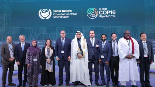
Noonu Atoll Participation in COP16 to Address Climate Challenges
Our delegation will participate in COP16 in Riyadh. A key opportunity to discuss solutions for land degradation, water scarcity, and ecosystem restoration while engaging in the Mayors’ Forum & WEF Roundtable.
Noonu Atoll Council
press
-y7B8z.webp)
Protecting Nature, Preserving Livelihoods: A Stand Against Unsustainable Tourism at COP16 Mayor's Forum
At COP16 Mayor's Forum, Noonu President shed light on the urgency of protecting natural resources and combating climate change and how unsustainable tourism is depriving Maldivian communities from right to nature. Advocating for transparent governance and local empowerment, he called for sustainable solutions to safeguard ecosystems and livelihoods
Noonu Atoll Council
press
-aeI-l.webp)
Commitment to Nature-Positive Strategies Highlighted During Our Participation in COP16 Urban Desertification Session
Participating in COP16's 'From Sand to Soil' session, we reaffirmed our commitment to nature-positive solutions. Collaboration is key to tackling urban desertification and building resilient, sustainable communities. 🌱
Noonu Atoll Council
press
Canada Fund for Local Initiatives Grant Empowers "Reimagine Noonu Atoll Binaaveshi Project"
in 2024, the "Reimagine Noonu Atoll Binaaveshi Project" gained crucial support from CFLI through our partnership with Land Sea Maldives. 🌿 Together, we’re driving sustainable development, inclusive governance, and resilient communities in Noonu Atoll.
Noonu Atoll Council
press

Invitation for Bids - Re-Tender: Announcement for Consultants
Calling all consultants! Join us in shaping the future of Noonu Atoll. The "Reimagine Noonu Binaaveshi" project invites experts to develop a plan empowering communities to sustainably manage resources. Register by Jan 25, 2025 & attend the session on Jan 27
Noonu Atoll Company
announcement

Visit of His Excellency Eric Walsh to Noonu Atoll
We’re honored to welcome H.E. Eric Walsh, High Commissioner of Canada, to Noonu Atoll (Jan 28-30)! Join us for the launch of the Reimagine Noonu Binaaveshi Project & free legal consultations by PILC! 🏝️ Key events in Manadhoo, Kudafari & Maafaru—your voice matters!
Noonu Atoll Council
press
Resignation Announcement of Noonu Atoll Company Managing Director
Mr. Hussain Riyaz, the Managing Director of Noonu Atoll Local Authority Company (LAC) Ltd., has announced his resignation, effective 15th November 2024.
Noonu Atoll Company
announcement
-20EAR.webp)
Get Ready for the Noonu Inter-School Sports Fiesta 2024!
The Noonu Inter-School Sports Fiesta 2024 kicks off Dec 17! 🏐⚽ Watch schools compete in futsal (Dec 17-20) & handball (Dec 20-21). Can't join in person? Catch all the action live on our Facebook page!
Noonu Atoll Council
press
-3veK2.webp)
A Dazzling Start to the Inter-School Sports Fiesta 2024
🎇 The Inter-School Sports Fiesta 2024 kicked off in style! A dazzling fireworks display lit up the night, followed by Lhohee School's 8-0 win in the opening futsal match against Fohdhoo School. 🌟 The Manadhoo Dance Team's performance added cultural brilliance. Huge thanks to Manadhoo Council for their support! 🤝⚽
Noonu Atoll Council
press
-sYHlG.webp)
Lhohee School Triumphs as Champions of the Noonu Inter-School Sports Fiesta 2024
🏆 Congratulations to Lhohee School on becoming the Futsal Champions of the Noonu Inter-School Sports Fiesta 2024! With stellar teamwork and skill, they secured a 2-0 victory against Meyna School in the finals. A proud moment for the entire community! ⚽💪
Noonu Atoll Council
press

Showcasing Noonu Atoll’s Vision for Sustainability at the Strong Cities Network
Noonu Atoll showcased sustainability at the Strong Cities Network workshop, highlighting initiatives like Reimagine Noonu Binaaveshi, Citizen Centric Governance, and Support Local. Through collaboration and innovation, driving progress for resilient, inclusive communities.
Noonu Atoll Council
press

Citizens' Treasury Management Workshop in Action
The Citizens' Treasury Management Workshop is underway in Noonu Atoll! Local councils are gaining insights into the Public Finance Act, procurement, accounting & more.
Noonu Atoll Council
press

Noonu Atoll Council Engages with Climate Vulnerable Forum for Climate Prosperity Planning
Collaboration is key to Noonu Atoll’s vision for a sustainable future. By uniting local communities, global partners, and innovators, the Atoll aims to create inclusive solutions that address climate challenges while uplifting livelihoods. 🌿
Noonu Atoll Council
press

High Commissioner of Canada Meets with Maafaru Council and Women's Development Committee
H.E. Eric Walsh, High Commissioner of Canada, met with Maafaru Council & WDC to discuss ongoing projects, financial challenges, solar energy plans, and waste management efforts. NGOs can apply to the Canada Fund (open till Feb 6, 2025) to support local initiatives.
Noonu Atoll Council
press

Public Forum in Kudafari Discusses Reimagine Noonu Atoll Binaaveshi and Community Concerns
The Reimagine Noonu Atoll Binaaveshi Project was presented at a Kudafari forum, focusing on sustainable land use, resource management & community well-being. Concerns raised included leasing uninhabited islands & environmental impacts. H.E. Eric Walsh, Canada High Commissioner, attended.
Noonu Atoll Council
press
-StC72.webp)
Canada High Commissioner Meets with Noonu Atoll Council and Partners
H.E. Eric Walsh, Canada High Commissioner, joined Noonu Atoll Council & partners to discuss the Reimagine Noonu Binaaveshi Project. Key topics included transportation (Maafaru Airport), resource management, and allocating islands for farming.
Noonu Atoll Council
press
-bySU8.webp)
H.E. Eric Walsh Joins Discussion with Manadhoo Council Regarding Development Plans and Waste Management
H.E. Eric Walsh met with the Manadhoo Council to discuss ongoing projects, future plans, and waste management challenges, including ocean dumping due to limited options.
Noonu Atoll Council
press

Invitation for Bids: Establishing CORS Surveying System in Noonu Atoll
Noonu Atoll launches GNSS & CORS Surveying System! Bids open 19 Feb 2025 to install a 25km-radius CORS for land planning & infrastructure. Join us to shape a sustainable future.
Noonu Atoll Company
announcement

Seeking a Marketing and SME Promotion Specialist
Noonu Atoll Administration seeks a creative Marketing Specialist to boost our brand! Craft campaigns, manage digital presence, create content, and drive results. Need 2+ yrs exp, Dhivehi/English skills. Apply with CV & cover letter to hr@noonunaturally.com by 14:00, Feb 26, 2025.
Noonu Atoll Company
jobs
Service Contract Opportunity – Urban Planning Consultant
We are seeking a qualified and experienced Urban Planning Consultant for the project Reimagine Noonu Binaaveshi – Development of the Noonu Atoll Land Use Plan (LUP).
Noonu Atoll Company
announcement
-6t1q_.webp)
Service Contract Opportunity – Socio-Economic Consultant
We are seeking a qualified and experienced Socio-Economic Consultant to contribute to the project Reimagine Noonu Binaaveshi – Development of the Noonu Atoll Land Use Plan (LUP).
Noonu Atoll Company
announcement

Service Contract Opportunity – Legal Consultant (Retainer)
We are seeking a qualified Legal Consultant (individual or firm) to establish a strategic legal partnership on a retainer basis.
Noonu Atoll Company
jobs
Seeking a Environmental Specialist
Noonu Atoll Administration is seeking a skilled and motivated Environmental Specialist to develop, implement, and oversee our environmental and sustainability initiatives, while also being responsible for a range of tasks related to geospatial data. The ideal candidate will be passionate about sustainability, possess strong regulatory and environmental management skills, and be capable of integrating environmental data with spatial analysis to support informed decision-making and project implementation.
Noonu Atoll Company
jobs
Seeking an experienced Operations Manager
Noonu Atoll Administration is seeking a highly organized and detail-oriented Operations Manager to provide proactive leadership in overseeing the daily operations of our company and managing our human resources functions. The ideal candidate will be a solutions-oriented problem-solver with exceptional communication and interpersonal skills, capable of fostering a positive, compliant, and productive work environment.
Noonu Atoll Company
jobs
Invitation for Bids: Provision of External Audit Services
Noonu Atoll Administration invites eligible and qualified audit firms to submit proposals for the provision of external audit services for the financial year 2023 and 2024.
Noonu Atoll Company
announcement
Invitation for Bids: Comprehensive HR Management System for Noonu Atoll Administration
Noonu Atoll Administration invites eligible and qualified parties to submit detailed proposals for the development and deployment of a comprehensive Human Resources (HR) Management System within a Microsoft 365 environment.
Noonu Atoll Company
announcement

Noonu Atoll Administration Partners with Thaana AI to Revolutionize Dhivehi Language Transcription
Noonu Atoll Administration teams up with Thaana AI to revolutionize governance with AI-powered Dhivehi transcription and auto-translation of council websites and announcements. Supported by Kendhikulhudhoo, Kudafari, Manadhoo, Maalhendhoo, and Maafaru Council, this initiative promotes transparency and engagement.
Noonu Atoll Company
press
Invitation for Bids - Re-Tender: Provision of External Audit Services
Noonu Atoll Administration invites eligible and qualified audit firms to submit proposals for the provision of external audit services for the financial year 2023 and 2024.
Noonu Atoll Company
announcement
Invitation for Bids - Re-Tender: Comprehensive HR Management System for Noonu Atoll Administration
Noonu Atoll Administration invites eligible and qualified parties to submit detailed proposals for the development and deployment of a comprehensive Human Resources (HR) Management System within a Microsoft 365 environment.
Noonu Atoll Company
announcement

Noonu Kudafari Pioneers Sustainable Waste Management with the Takakura Method
Noonu Kudafari’s waste initiative turns food waste into resources using the Takakura Method, setting a new standard for island sustainability.
Noonu Atoll Company
press
Invitation for Bids - Re-Tender: Provision of External Audit Services
Noonu Atoll Administration invites eligible and qualified audit firms to submit proposals for the provision of external audit services for the financial year 2023 and 2024.
Noonu Atoll Company
announcement

Noonu Atoll Quran Festival 2025
Noonu Atoll Council has officially announced that applications are now open for island councils seeking to host the prestigious Noonu Atoll Quran Festival 2025. Scheduled to take place from 20 to 23 August 2025.
Noonu Atoll Council
press

Six Islands Join OneGov Platform in Partnership with Atoll Council
A landmark collaboration has been achieved as six Island Councils from Noonu Atoll have officially joined the innovative OneGov platform, partnering with the Atoll Council to drive digital transformation in the Atoll.
Noonu Atoll Council
press

GNSS & CORS Surveying Training Opportunity
Join our GNSS & CORS Surveying Training on 12th July 2025 to gain hands-on experience with advanced techniques. Enhance your skills, network with experts, and contribute to a progressive professional community. Don't miss this opportunity to stay ahead in your field!
Noonu Atoll Council
announcement

Invitation for Bids - Drone Surveying of Noonu Atoll Islands
Explore Noonu Atoll islands, lagoons, and reefs through drone surveys! Join a project promoting sustainable development and biodiversity protection. Service providers can register from 18 July 2025.
Noonu Atoll Company
announcement

Invitation for Bids – Consultancy for Island Takakura Model Rollout
oin Noonu Atoll's Organic Waste Management Project! 🌱 Implement sustainable composting systems using the Takakura method. Bids open July 13, 2025. Showcase your expertise in training, SOPs, and technical support. Let’s create a circular economy together!
Noonu Atoll Company
announcement
Zero Waste Maldives Leads Implementation of Hazardous Waste Solutions: Under SWAP Program
Zero Waste Maldives drives progress in Noonu Atoll through SWAP, reducing hazardous waste & empowering safer practices. Workshops & the new Fibreglass Waste Guideline highlight collaboration & innovation.
Noonu Atoll Council
press

Vehicle License Exam Track Project Advances in Commitment to Public Service Enhancement
The vehicle driving license practical exam track project, funded through the Noonu Atoll Council's block grant, is now back on track after resolving technical challenges. With plans for an adjacent park underway, we thank Manadhoo Island Council for land allocation and the contractor for their dedicated effort.
Noonu Atoll Council
press
Noonu Atoll Council at COP16 Mayors' Forum
The "Noonu Atoll Council COP16 Brief" highlights the council's participation at the COP16 Mayors' Forum, emphasizing their advocacy for sustainable development, balancing tourism with environmental preservation, and addressing climate challenges. It showcases their commitment to integrating local perspectives into global climate solutions.
Noonu Atoll Council
press
-zRT0O.webp)
Council urges the withdrawal of the Government’s proposed amendments to the Decentralization Act
Noonu Atoll Council opposes Bill No. 2025/20/B-18, warning it would weaken local councils by limiting projects, cutting revenue, and restricting staffing. The bill also risks unfair central government influence in elections. The Council urges its withdrawal to protect local governance and public participation.
Noonu Atoll Council
press
Noonu Velidhoo will host Noonu Atoll Quran Festival 2025
Noonu Atoll Council is pleased to announce that Velidhoo will host the 2025 Noonu Atoll Quran Festival from August 20–23.
Noonu Atoll Council
press
Invitation for Bids - Re-Tender: Provision of External Audit Services
Noonu Atoll LAC Ltd., a company under the Noonu Atoll Council, invites qualified external auditors to submit proposals for the audit of financial statements for the years 2023 and 2024
Noonu Atoll Company
announcement

GNSS surveying training opportunity in Maafaru
Calling all municipal and land service staffs, surveyors, engineers, planners, GIS professionals and interested parties to join our training session.
Noonu Atoll Council
announcement

Join Noonu Atoll Council as a Council Officer - Permanent Position
Noonu Atoll Council seeks Council Officer to manage administrative tasks, meetings, and council records. The position also involves supporting Atoll Councilors with their administrative needs.
Noonu Atoll Council
jobs
-T1Ekr.webp)
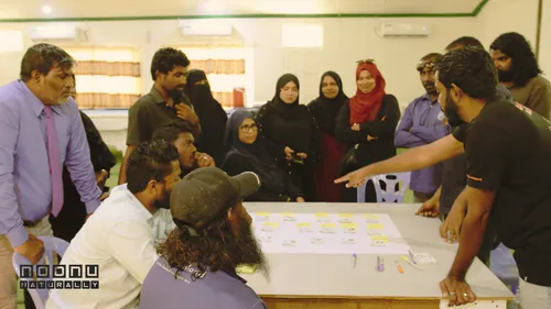
Atoll Wide High Precision Survey Initiative: 13 Islands to be Mapped for informed, data driven development
We have successfully completed GNSS & CORS training and mapped Maafaru Island with exceptional accuracy. Our next mission focuses on surveying islands to strengthen informed, data driven development and environmental resilience across the Atoll.
Noonu Atoll Council
press
Noonu Atoll Quran Competition Begins July 20 in Velidhoo
Noonu Atoll Quran Competition will start on July 20 at 8:30 PM at the Noonu Atoll Education Center, Velidhoo, featuring 181 participants from schools across the atoll. The event will be live-streamed on our official Facebook page
Noonu Atoll Council
press
Lobby and Local Market area construction at Noonu Atoll Convention House
Construction of the new Lobby Area at Convention House starts this Sunday. A modern space with a local market is coming soon.
Noonu Atoll Company
press
Invitation for Bids - Re-Tender: Provision of External Audit Services
Noonu Atoll LAC Ltd. is seeking an independent auditor to review its financial statements for 2023 and 2024. Interested firms must register online by 2 September 2025, 18:00 hrs to participate.
Noonu Atoll Company
announcement
Noonu Atoll Quran Festival 2025 Concludes with Remarkable Student Participation and Honors
The Noonu Atoll Quran Festival 2025 concluded in Velidhoo with 181 students showcasing excellence in Quran recitation.
Noonu Atoll Council
press
Takakura Community Composting Project – Call for Island Council Proposals
Island Councils of Noonu Atoll are invited to submit proposals for hosting community composting facilities using the Takakura Method. Join us in transforming food waste into compost and building a greener, self-sufficient future.
Noonu Atoll Council
announcement
-W0ZRL.webp)
Noonu Atoll Council Extends Support to Students Competing in 37th National Quran Competition
Noonu Atoll Council is supporting students traveling to Malé for the 37th National Quran Competition.
Noonu Atoll Council
press
Invitation for Bids: Composting Equipment Supply for Noonu Atoll Islands
The Noonu Atoll Council invites qualified suppliers to submit proposals for the supply, delivery, and commissioning of composting equipment to support a decentralized food waste management initiative across all inhabited islands in Noonu Atoll. This project utilizes the Takakura method to promote sustainable composting practices and circular economy principles. Bidders must provide complete proposals including equipment specifications, delivery timelines, and proof of relevant experience. The deadline for submission is 13 October 2025 at 14:00 hrs, and registration of interest closes on 9 October 2025.
Noonu Atoll Company
announcement
-k_A1z.webp)
Noonu Atoll Council Signs Tripartite Legal Consultancy Agreement with Lawcraft LLP
Noonu Atoll Council has entered a strategic partnership with Lawcraft LLP, officially appointing the firm as its legal counsel after a unanimous resolution. This collaboration will ensure comprehensive legal support across all Maldivian legal forums, strengthening local governance and compliance. The effort, supported by a rollout toolkit, will provide advisory services, training, and transparent legal delivery to bolster decentralized administration.
Noonu Atoll Council
announcement
-HyzGX.webp)
Call for Proposals – Meeting Management System
Noonu Atoll Council invites qualified vendors to submit proposals for developing a Meeting Management Application on the Microsoft Power Platform. The solution must integrate with Microsoft 365 services like Teams and Outlook to enhance meeting governance and productivity. Bid submission deadline is October 22, 2025.
Noonu Atoll Company
announcement
Invitation for Bids - Re-Tender: Composting Equipment Supply for Noonu Atoll Islands
The Noonu Atoll Council invites qualified suppliers to submit proposals for the supply, delivery, and commissioning of composting equipment to support a decentralized food waste management initiative across all inhabited islands in Noonu Atoll. This project utilizes the Takakura method to promote sustainable composting practices and circular economy principles. Bidders must provide complete proposals including equipment specifications, delivery timelines, and proof of relevant experience.
Noonu Atoll Company
announcement
-g2xhX.webp)
Visit of the Australian High Commissioner to Noonu Atoll
His Excellency David Jessup, Australian High Commissioner to the Maldives, met with the Atoll Council and island leaders to discuss decentralised governance, sustainable development, and cultural preservation. His engagements in Manadhoo highlighted the importance of community-led initiatives and international cooperation.
Noonu Atoll Council
press
-ekI9J.webp)
Vehicle Driving License Exam Track Officially Completed in Commitment to Public Service Enhancement
we are proudly announces the full completion of the 20,800 sq ft vehicle driving license practical exam track. Delivered at a total cost of MVR 1,085,942.21 using council resources, the facility awaits final government approval and will soon be open for public use in license testing and training. Heartfelt thanks to Sea Shine Investment and Manadhoo Island Council for their vital contributions.
Noonu Atoll Council
announcement
Noonu Atoll Council Awards Contract for Supply, Delivery, and Commissioning of Waste Management Equipment
On 18 November 2025, Noonu Atoll Council officially awarded the contract for the supply, delivery, and commissioning of advanced waste management equipment. All items will be delivered within 45 days, marking a major step toward stronger, more sustainable waste management systems across the atoll’s 13 inhabited islands.
Noonu Atoll Council
press